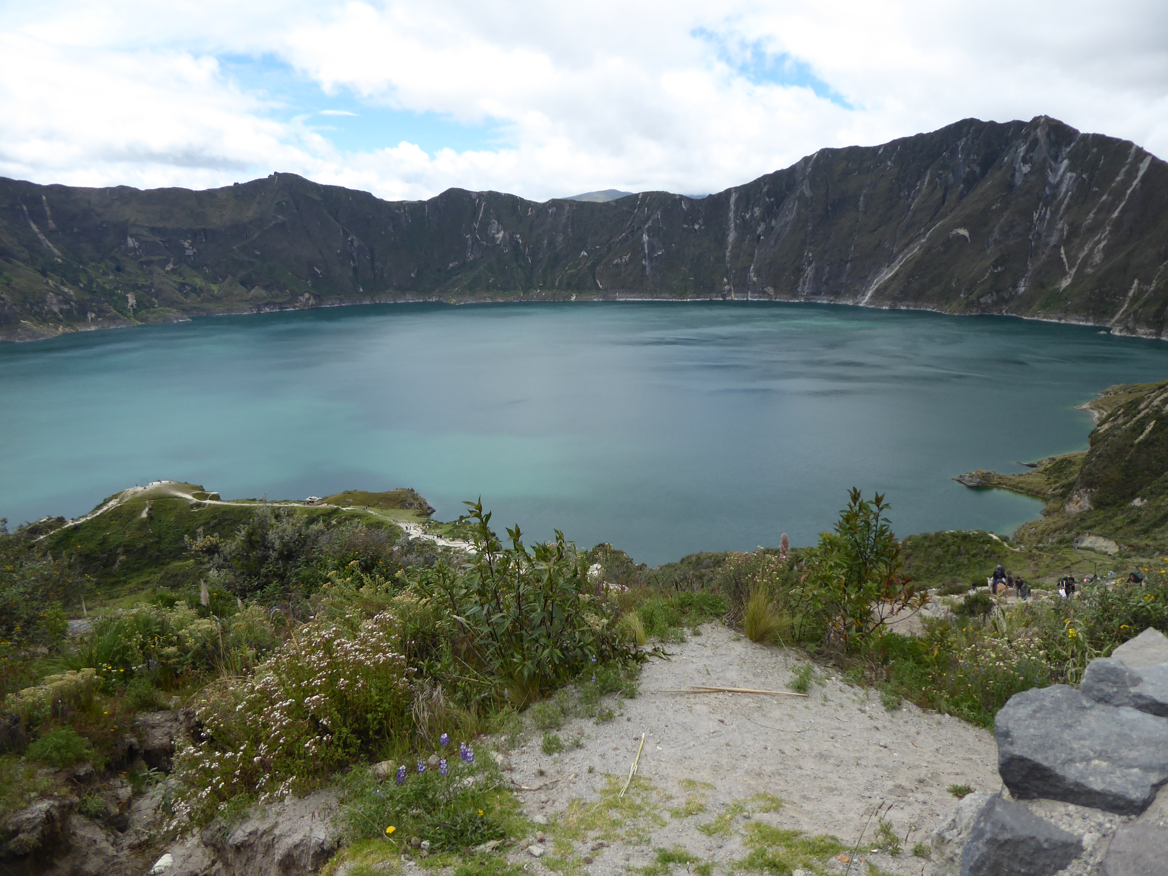
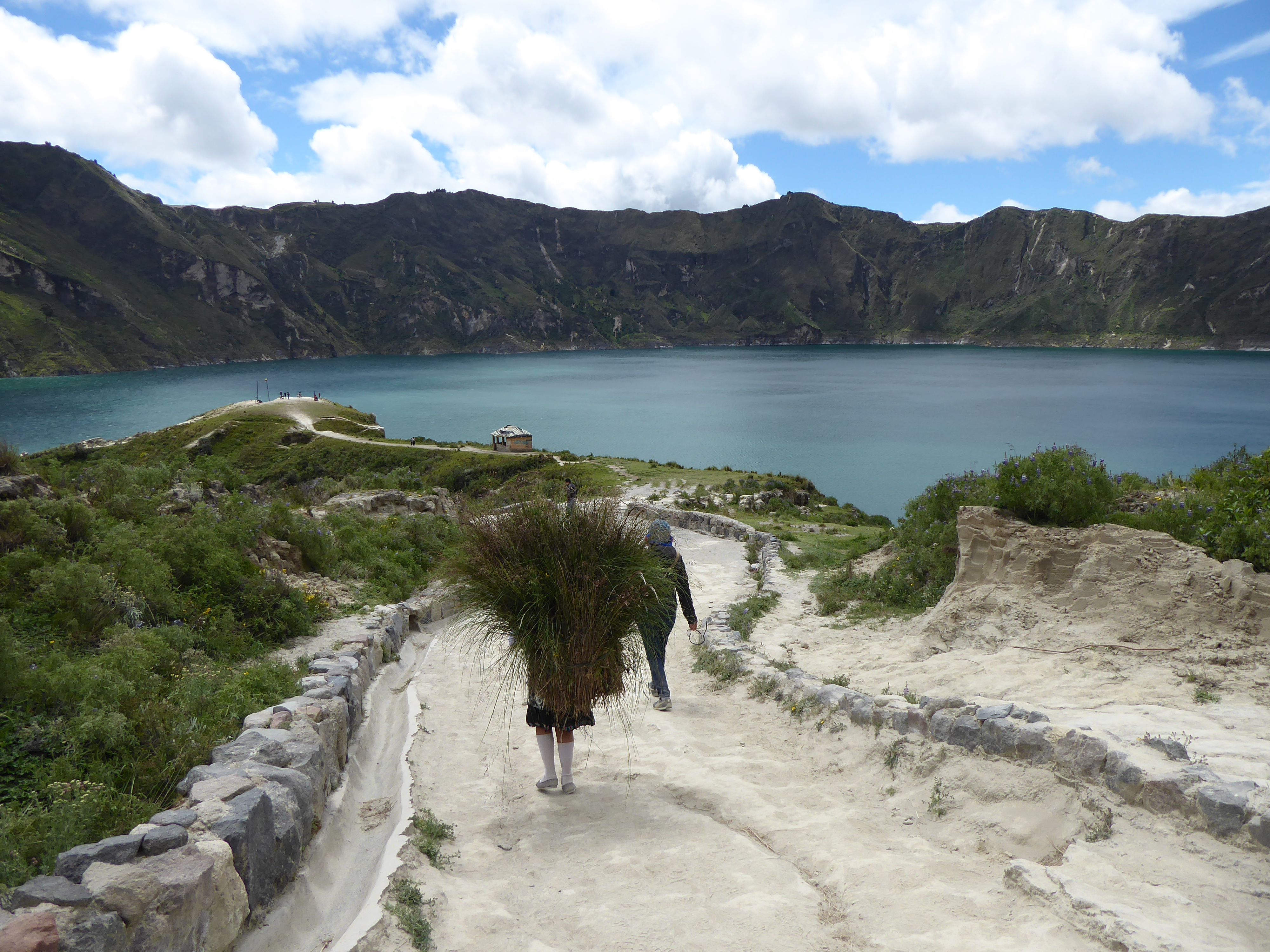
 The crown jewel of the Quilotoa region is its crystalline crater lake. Extremely strong gusts of wind dissuaded me from walking along the crater’s rim, but the 400 meter walk from the rim down to the lake had its own challenges. The narrow, serpentine, loose path was very steep and walkers competed for space with the donkeys that transported tourists up from the bottom. After enjoying the view, I made my way back up with considerable effort and frequent stops. Passing me were the local men, women, old and young, and children who guided the donkeys up and down several times a day or carried necessities.
I spent the night in a comfortable hostal offering private bed and bath with a wood burning stove, dinner and breakfast for $15. There I met Faye, from South Korea, who was hiking to Chugchilan, about 13kms away, the following day. I was tempted and we decided to hike together.
Equipped with a map, and the maps.me app we set off around 10am. Faye confidently led the way. The beginning was not auspicious. Shortly into our hike some dogs came out from their domain and Faye was bitten. Frightened, but not deterred Faye now with a good bruise on her leg, decided to walk on. The dogs’ owners made amends by arming us with a sturdy stick to ward off any other aggressors. We picked up two more.
We verified our route with the family and continued hiking. The terrain was hilly. The path sandy and rocky. The landscape was dotted with small settlements of wooden and cement shacks and patches of crops. Signs with arrows confirmed our path as did the maps.me app. All seemed in order until we arrived at “a bridge” crossing a ravine. The “bridge” was a single tube that went the length of the wide gap hoisted with several vertical cables attached to a single cable above. Crossing it would require shimming horizontally along the tube with arms used for guidance and moral support. It was a daunting passage, but the well worn path on both sides gave 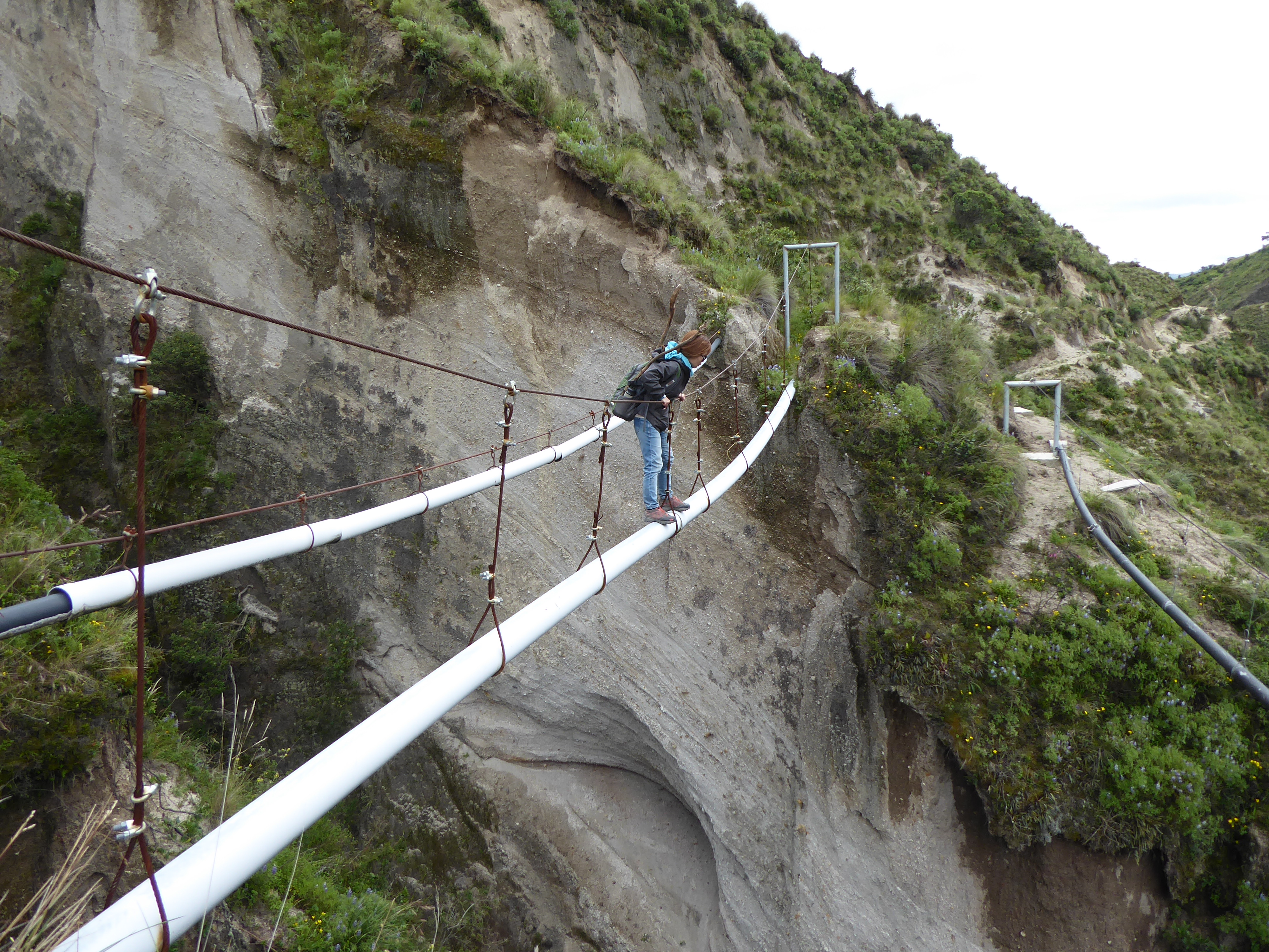 us confidence. (I had seen people using similarly funky bridges in Asia.) “People must use this all the time.” I said.
Faye went first. Standing about 4’10″(1.47 meters) she struggled to reach the cable above that sloped down toward the middle, but she got across. My going second gave me just enough time to get thoroughly spooked. The sway of the pipe did nothing to ease my nerves, but I too-with some much needed encouragement midway-got to the other side. We congratulated ourselves for our accomplishment and walked on–so elated as to not notice the precarious path we were embarking on.
Moments later the precipitous path could no longer be ignored. It narrowed to less than a foot in width with a cliff on one side and a very deep drop on the other. Adding further concern, the path itself with a tilt toward the abyss was loose sand of inconclusive weight bearing capacity. The situation was clear to me. We would not survive a fall. Faye wanted to forge on. Her small feet fit the path better than mine. My survival instincts kicked in. I wasn’t taking another step forward and the only movement I managed was with my mouth uttering a word beginning with F. Even the small patch of earth I was sitting on felt uncomfortably unstable. Talking with Faye calmed me, but I was not willing to walk on.
Unfortunately, the only alternative was traversing back over “the bridge”. Faye and I had different fears. I preferred the bridge to the path. The sky was darkening and rain would definitely make the path even more treacherous than I was certain it already was. It didn’t take long for us to agree-we made a good team-to go back over the bridge. I thought of Philippe Petit, who walked on a high wire between the Twin Towers, for inspiration. Faye prayed.
The crossing was without incident. We forged up some steep, but passable hills in search of a road. Some school children pointed us in the right direction and soon after we hitched a ride to Chugchilan.
Sharing our exploits with the driver, he concurred that we had been on the right path all along…until we showed him the picture of “the bridge.” “That’s not a bridge, that’s a water pipe!” I won’t describe the look of horror on his face.
We repeated our tale anticipating the-now that we were out of danger-amusing reactions of dismay. We were not disappointed. The photos clinched it. (People asked to take photos of our photos to show their friends.)
“You’re safe now.” one man kindly conceded. “That’s all that matters,” he added. When we tried to justify our choice by repeating the advice of the locals and following the signs, we learned the path had become too dangerous from erosion. “It’s suitable for goats, not people.”
But why the path came to and continued beyond “the bridge” remains a mystery.
I slept relatively well in Chugchilan that night relieved that disaster had been averted but questioning my judgment at arriving in such a predicament.